 |
| Somewhere in the Wildschönau, looks like one of those old postcards |
Heading from A to B can be an interesting, sometimes demanding task. Most people will take a car, some people public transport, if available, some a bicycle and not too many will walk, especially when the distance is bigger than the way from the sofa to the fridge. I generally vow for the last one, why, I like it. So quite some time ago I made the decision to walk from the Saulueg in Kundl to Thierbach in the Wildschönau. Just for the sake of it and to take a look at both places.
 |
| At the beginning it looked like that |
The starting point was a good old, traditional concrete road with nearly none to zero traffic at all. After a sharp turn to the right I found out where: A farm built in traditional regional style and a few weekend homes. After passing the buildings the road turned into a gravel path with a second, not that well constructed way heading uphill. Despite a sign saying "Thierbach this direction" and showing on the better built way, I decided to head upwards. Looked to me like the more interesting thing to do.
 |
| The way ended a few meters behind, but isn't there another road just upside? At least according to GoogleEarth... |
In the beginning i seriously thought I made the right choice. The steep path developed into a nice walk able way. But then a theoretically foreseeable thing happened: The way found an end. In the middle of the forest. At a place where all trees have been cut down. So with the help of some luckily not too old satellite images (Google Earth, I really like you...) I found a solution for my problem: Just straight up the clearing on the above picture was something that looked like another road. So up I went. Not that I liked it, but it was doable to climb up the hill.
 |
| Yes, there was another way, but it headed on forever in that fashion. |
And there was a way. And the way went on, and on, and on and looked pretty much the same for the most of the time. Just a moderate climb for a few kilometers, don't think that it have been more than five. Listening to some music got me over that "I think I saw that tree already a few minutes ago" thing. At least I headed in the right direction.
 |
| As far as I remember, the first viewing point after one hour of trees |
After a while the scenery opened up and more and more viewing points came across the path. Not the most interesting ones I have ever seen, but as mentioned before, far better than a bright green tree followed by a darker one. So heading on got easier to do, hoping that after every turn something new waited to be discovered.
 |
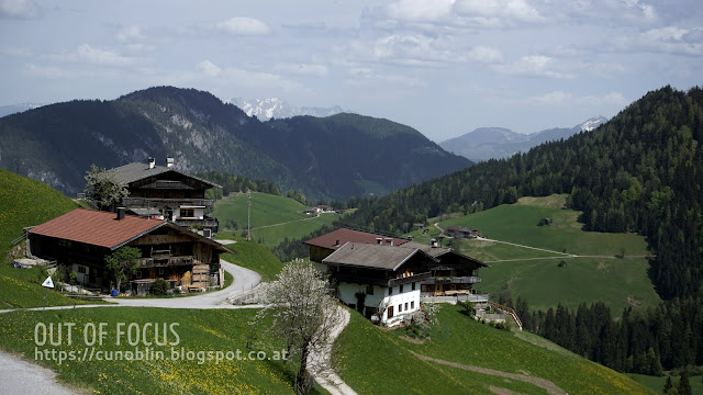
| Thierbach, a small village in the Wilschönau |
And then then finally the way left the forest and the gravel path lead into a concrete road. As far as I could find out, I made to my goal. I was in Thierbach Wildschönau, and it looked pretty much as I expected: Farm houses, roads, fields, the classic rural regional landscape, looked to a certain point like a postcard from the good old days. Just without a trashy blue sky.
 |
| Gratlspitz, the mountain in the middle |
Now that I was there, I had three opportunities: Head back where I came from. No, not the same boring way. Head into the village Thierbach and further down the valley to the next bus station and drive back home. Too many hours of daylight and provisions left. Head in further. The right thing to do. So I walked along the concrete road I stood on and headed past some really old looking farm buildings towards the next big and impressive mountain, the Gratlspitz.
 |
| A small chapel, the last turning point on my way up |
Nearby the base of them mountain, no I didn't plan to climb up there, not on that day, I came by a very nice looking small wooden chapel with some benches in front of it. The ideal place for the first longer break on that drip: Dinner time. After resting for a while, looking at the surrounding landscape and filling my stomach I headed on. Upwards, the stony path passing by the chapel, hoping that it would be the last time on that trip.
 |
| Up, for the last time on that trip |
It was quite a nice path to walk. Not to steep, not washed out by water and for the most time following the border of a forest. And then, a horizon appeared in my field of view. I made it to the highest point of that trip, the Holzalm was reached (not that i planned to get there, or knew of it's existence before I set a foot in this place, sometimes things just develop on the go). So the only thing that was left was to head back home, but that's a different story.
Well, now at the bottom, the usual social media blogging stuff: Feel free to comment, share and like. You can also follow me on Facebook or Twitter to get noticed when I wrote something similar. Or do that all in the old fashioned way and just tell someone about it while drinking a cup of coffee...
 |
| At the highest point of the trip, the Holzalm, or at least a very small part of it... |


